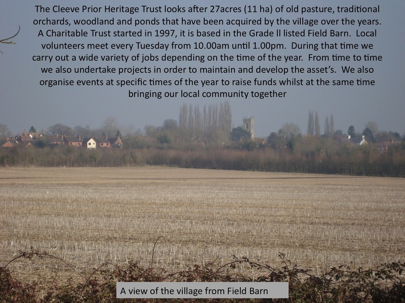
Heritage and History
Field Barn History up to 1997
The Grade 2 18th C Lias stone barn was built as a threshing barn and was part of the Manor Farm. Originally a single building, it was used predominantly for the storage of corn sheaves and hay as well as wagons and farm implements. The two wings were added much later. The South wing was a seven bay stable for the horses that worked the land. The open wing was a cattle byre, probably for milking cattle.
In the 1930’s, during the depression, it was acquired by the County Council, along with the associated fields behind it. Over the years it was leased by local growers but fell into a dilapidated state.
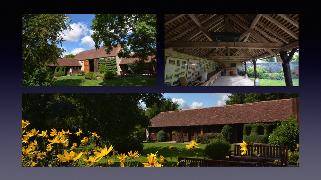
What you see today is thanks to the vision of Dr’s Lin and Don Warren who formed Cleeve Prior Heritage Trust in 1997, the hard work and generosity of the village of Cleeve Prior and grant aid. The Barn and land is held in Trust for the benefit of Cleeve Prior and its environs.
Market Gardening in the Vale
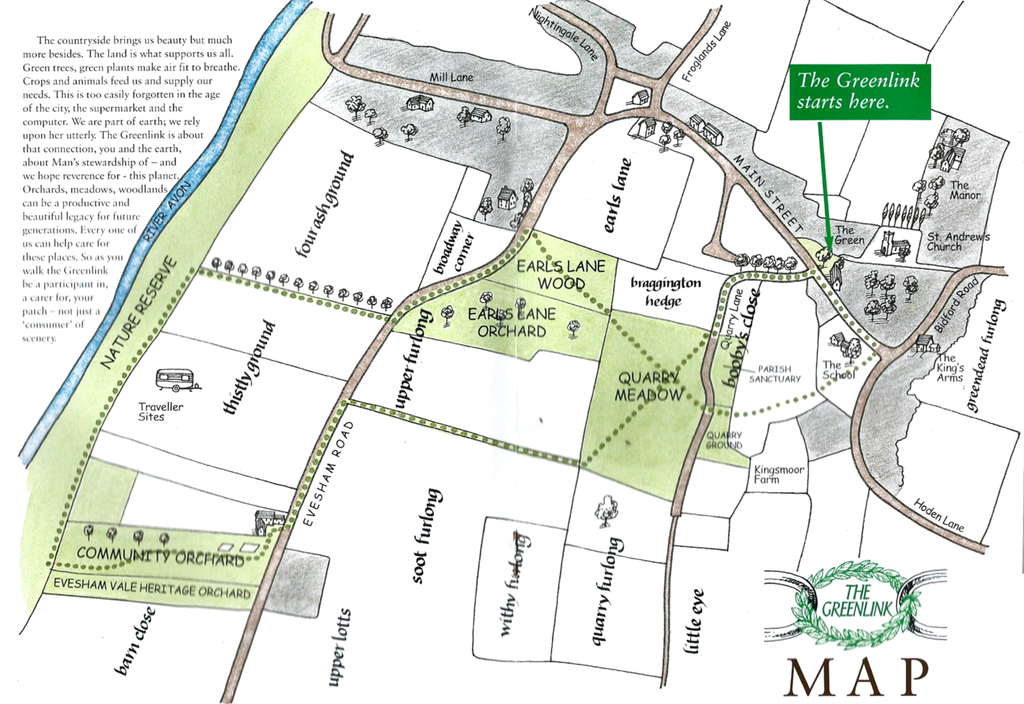
The land behind the barn was divided into numbered strips of one or two acres, only ten or twenty meters wide, but extending from the road across to the bridleway to the west. The strips were rented out to locals as part of the Farming Ladder scheme. Rents would have been low, and successful growers would be able to sustain a family and expand. At one time most of the population around Evesham and Pershore were employed in Market Gardening.
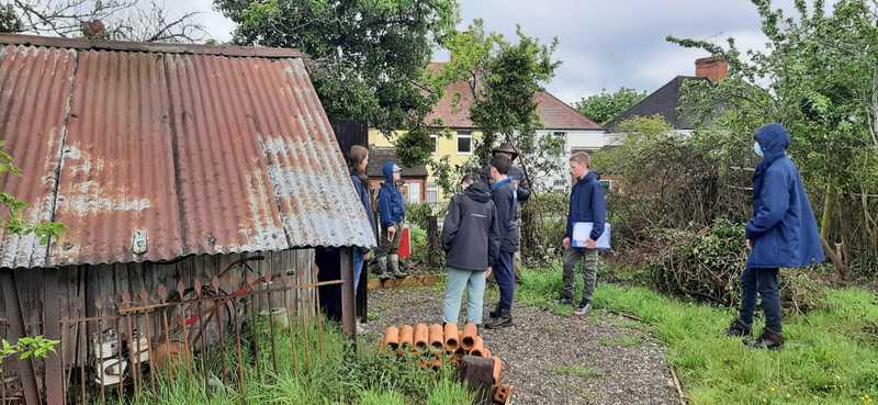
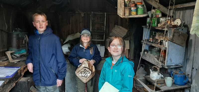
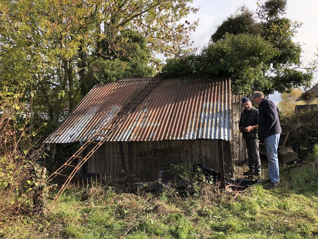
The ground is heavy clay, grade 3, and not easily worked. Perennial crops such as fruit trees, soft fruit, daffodils and asparagus would all fit into a system that gave income for the bulk of the year. Hence the Apple, Plum, Pear and Cherries were planted at wide spacings allowing for crops underneath. Rhubarb and vegetables such as Brussel sprouts, salad onions, leeks and cabbage would also have been grown in season. Most of the produce would have been sold in the local wholesale market in Evesham, or through the local Co-operative, Littleton and Badsey Growers at Blackminster. Most of the plums went to the local cannery in Evesham. The growers all built sheds or hovels on their plots of land to keep their tools and produce and to provide shelter. Grower’s or hired hands sometimes slept in them, especially when the cherries were ripening and the birds needed scaring away! Eric Wheeler’s Hovel was re-discovered as part of an Archaeological project which has focused on many aspects of market gardening in the Vale, but no more so than a tiny shed discovered in the corner of a field in Cleeve Prior, still full of the old artefacts as the last occupier left it some thirty years ago.
Find out about Eric Wheeler’s Hovel
https://www.explorethepast.co.uk/project/market-gardening-heritage/
Follow the link to the Cotswold & Vale Magazine article on Edgar Wheeler's hovel - https://valemagazine.org/wp-content/uploads/2021/03/249-Vale-Mag-E-MAG.pdf
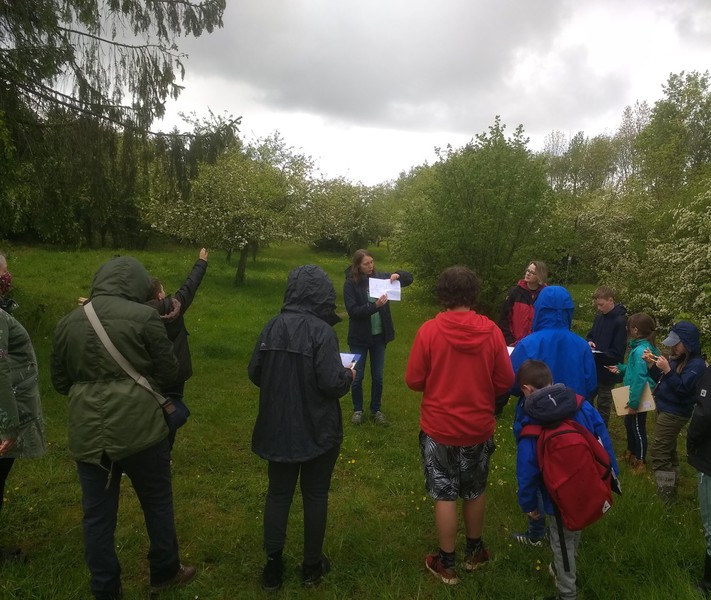
Worcestershire young archaeologists club visit to the hovel in May 2021
The Decline of Market Gardening in the Vale
When the UK joined the Common Market [now the EU], compulsory grading was introduced, with classes 1,2, and 3- along with associated paperwork, everything had to be labelled. Of course, nobody wanted class 2 stuff, hence the decline in demand for the bulk of the Vale produce, mirrored by the expansion of the supermarkets.
The orchards gradually fell into decline with ageing growers, and poorer returns. Veg and soft fruit gave way to grass and sheep, or nothing, and reverted to scrub. At the same time, late 1970’s, the government introduced the Orchard Grubbing Grant, to help farmers replace the plum orchards with more profitable crops.
The Focus today
There is a mixed picture in and around Evesham as retiring growers sell off land for development. What sadness for many local people seeing the sale of the wonderful cherry orchard now a housing development. However, the importance of local heritage supported by grants to preserve and restore old orchards has been successful in the Vale with Vale Landscape Heritage Trust
https://www.worcestershireorchards.co.uk/orchard-groups/


Cleeve Prior History
Cleeve Prior has considerable architectural and historic interest, with more than a thousand years of settlement history and a wealth of historic buildings, ranging from manor house to dovecote. The use of local blue lias stone and local detailing through all building types and periods gives the village a strong character and local identity.
Its Early origins as a farming community, within a wider area of Saxon and Medieval settlement activity, is still evident in its buildings, layout and in the archaeology and hedge patterns of surrounding fields.
The continuing significance of agriculture throughout Cleeve Prior's development is clearly illustrated in the presence of numerous farm buildings and farmhouses from the 16th, 17th, 18th and 19th centuries. These are present throughout the village and are a significant element of its character and special interest.
The village has seen only modest new development and has been little spoiled, retaining much of its historic plan, historic buildings and fabric and open spaces, and in the absence of newer development at its periphery, has maintained a strong visual and historic connection with its agricultural hinterland.
There are several clues in its landscape setting to its history. Areas of ridge and furrow (remnants of the medieval open field system) are overlaid by patterns of small linear fields from early enclosure, and larger regular shaped fields from 18th century enclosure, indicating a long history of farming activity. Old orchards and a radiating network of narrow lanes and tracks are other surviving clues of an historic settlement.
Neolithic, Bronze Age, Iron Age and Roman Periods
The Avon valley, with its gentle climate, fertile soils and river access, was a favoured area for Neolithic, Bronze, Iron Age and Roman settlement, and finds from these periods suggest a long period of settlement activity in the vicinity. The village and its immediate surrounds are particularly rich in Romano-British archaeology. Remains and finds include 2nd to 4th century wall foundations, pottery, jewellery and a remarkable discovery of some 400 gold and 2,000 silver coins. Other finds and remains include a burial site and a spindle whorl, suggesting an established community during the Roman occupation. The Roman road, Ryknild Street, known locally as Buckle Street, runs 2 km to the east of the village. A track along the bluff edge above the river is also Roman and believed to have been a loop road, joining up with Ryknild Street via Bretforton and on to Cleeve Prior.
Medieval Period. The Manor of Cleeve was given by Ethelred to the Prior of Worcester in AD872. The first written record of a settlement at Cleeve Prior comes in the Domesday Book of 1086 which records a priest, a mill and around 108 persons farming some 120 acres of surrounding land, indicating an established settlement by this early date. It was likely established as a farming community by the Prior of Worcester and worked by peasant tenantry of the monastic estate to contribute to support of the monastery at Worcester.
The land would have been cultivated in strips for arable crops, with grazing and hay meadows on either side of the river. Evidence of this early farming system still exists in remnants of ridge and furrow in fields adjoining the village at Manor Grange, Froglands Lane and Mill Lane, and in hedges defining the remains of strip fields on the north side of Main Street. A survey plan of the parish dating from 1772, prior to enclosure, shows much of the parish covered with the open field strip farming system, with riverside meadows and common grazing grounds.
The manor house and church would have been at the heart of this early medieval community. Both are still present. The church is the earliest surviving building in the village, dating from the 12th century. The present building may have replaced an earlier structure. The manor house dates from the 14th century, with a medieval dovecote adjacent. Dovecotes in this period were an indication of status and restricted to the Lords of the Manor and monastic lands. A second dovecote is sited behind later buildings fronting The Green. These are rare survivors and clues to links with the Worcester monastic estate and to the former role and status of the manor house.
There have been 13th and 14th century finds in the village, including pottery, a casket key and a spindle whorl. These finds, together with occasional surviving buildings from this period, suggest settlement into the medieval period. There are remains of ridge and furrow adjoining the east side of the village, behind Main Street, the church and manor house, and in Quarry Lane. A survey plan dating from 1772 indicates that ridge and furrow would once have covered much of the parish, although much has since been ploughed out. These remnants in and around the village are tangible reminders of this period of settlement activity in Cleeve Prior's history.
Early Modern Most of the earliest surviving buildings are substantial stone houses dating from the16th century. These are scattered throughout the village, along Main Street, The Green and Cleeve Road, indicating that its layout was probably well established by this time. Lanes and paths branching to the north, south and west would have given access to the surrounding fields, and to the river, the mill and ford to the meadows beyond. A concentration of these early buildings around a large triangular area at the junction of Main Street and Cleeve Road suggests the former presence of a large area of open space. 18th century maps show some of it as a Green with a pond, and it is likely that the larger area delineated by these early buildings was once common land used for grazing and village gatherings. Much of it has since been encroached on by development. Its former extent can still be identified in features that continue to the present day, in the footpath and track running to the south of the church to Cleeve Road, the south-western boundary of the school grounds and the line of properties fronting Cleeve Road. The green and school playing fields there today are the remnants of this space.
The presence of a number of early substantial houses suggests prosperity in Cleeve Prior in the Tudor period. These houses were probably the homes of Yeoman farmers, reflecting a widespread prosperity and re-building in this period. These stone houses are likely to have replaced smaller timber framed structures, and to have begun a transformation of the appearance of the village into one of predominantly stone buildings that we see today. There are still examples of surviving timber frame, and these are a reminder of how the village may once have looked.
Modern Period A large number of 17th and 18th century cottages, houses and farm buildings suggests a continuity of the prosperity enjoyed in earlier years, probably fuelled by the naturally favourable growing conditions of this area, coupled with agricultural improvements and enclosure of the common fields in 1775. By the 18th century the River Avon was open to navigation from Bristol to Stratford. This may also have influenced growth by giving easier access to neighbouring markets and those further afield. Farms from this period are sited throughout the village, along Main Street, Cleeve Road and Nightingale Lane, as well as on part of the former common land in the heart of the village. It is likely that many are sited on an amalgamation of former smaller plots, and that the stone buildings from this period would have replaced older structures, continuing the process of building renewal begun in the previous century.
The 19th century saw limited new development, mainly farm buildings and small infill developments of workers' cottages and modest houses. The First Edition Ordnance Survey map from the 1880's shows little change to the form of the village and no expansion beyond its limits shown in 18th century mapping. The map shows the remains of much of the former green taken for development of the school. Noake's Worcestershire observes that the inhabitants were "exclusively engaged in agriculture - women as well as men". The 1876 Post Office Directory of Worcestershire records a population of 294 (in 1871), and a predominance of farmers, as well as a miller, maltster, blacksmith, carpenter, iron founder and shopkeeper.
Contemporary Period Cleeve Prior has seen only modest 20th century development, with limited new infill and peripheral development. The historic centre of the village remains much as indicated by 18th and 19th century mapping. There are still two working farms but most of the former farm buildings have been converted to houses. Nevertheless, the former identity of many of these former agricultural buildings is still evident and they remain as clear evidence of the village's development. Those that haven't been converted remain unaltered and retain their identity, and these buildings make a valuable contribution to the character and special interest of the conservation area. The Neighbourhood Plan specifically refers to the importance of maintaining the historic agricultural setting of the Village.
Archaeology
Cleeve Prior has a long north-west/south-east Main Street linear axis, possibly the development of a pre-existing route between the river and Ryknild Street. The main street curves sharply at each end, with narrow lanes branching off, terminating at the river or reduced to tracks and bridleways. A small triangular green partway along the length of Main Street marks the onetime presence of the old green/common area.
This framework of roads, lanes and tracks is likely to be medieval, or earlier, in origin, and appears little changed.
Clusters of individual houses, cottages and farm buildings line both sides of the roads and lanes, with little uniformity in spacing between buildings or in their relationship to the road. Most of the older buildings sit immediately on to the road or footways, or are attached at the rear of frontage buildings, with gardens/farm yards at the rear. More recent buildings are set back with gardens extending to the front, sides and rear. Plots are a variety of sizes, though mostly linear, corresponding with the width of the principal building fronting the road, and terminating in a common rear boundary line. The majority of buildings carry their ridges in approximate alignment the road or lane, with only occasional older buildings presenting their gables.
Notably the manor house is set apart from the rest of the village near the church, while the remaining farms, smaller houses and cottages line the roads and lanes, reflecting the historic status and function of these principal buildings and social hierarchy of the village.
Less apparent, but just as important to the special interest and character of the conservation area, are less obvious private gardens. These remain as largely undeveloped and enclosed spaces that continue in use as gardens. While the full extent of these may not be entirely publicly visible, the lack of interruption by buildings and presence of planting contributes to an impression of space at the rear of the built up street frontages, appreciated from glimpses over boundaries, between buildings and from footpaths to the rear. These gardens also provide the setting of buildings and are the interface between the buildings on the road frontages and the fields abutting at the rear. Some of them are also historically important as the open space characteristically found behind frontage buildings in early settlements such as Cleeve Prior.
All of these spaces make a significant contribution to the character and appearance of the village and reflect its origins and history
Key Views, Vistas and Open Spaces
There are open spaces in the Cleeve Prior Conservation Area that are key to its character and special interest.
The fields abutting the rear of properties on the north side of Main Street and rear of the church and manor house contain remnants of ridge and furrow, as well as hedgerows that define the old strip fields. The retention of these fields and their features is important to understanding the historical development of the village, as well as to the preservation of its agricultural setting, and the settings of the church and manor house.
The village green is the most obvious remnant of the once much larger common area. The school playing field is the remainder. These open spaces are the remainder of the historic open space in the heart of the village and are an essential element of its special interest and rural village character.
There are several substantial garden spaces throughout the conservation area, including those at The Old Vicarage, Church Croft, School Cottages, the Manor House, Cleeve Barn, Kemises House, Prior House, Upper House and Lynwood. These gardens are obvious from roads and public footpaths. They provide the settings of many notable buildings and the open space they provide is an important element of the character and appearance of the conservation area.
There are several views of the village in its agricultural landscape setting. Those from public footpaths and bridleways to the north, east and west in particular give good views from public vantage points. From here the close relationship of the village to its rural setting, its layout and its history in the presence of historic field boundaries and archaeology, is obvious. Views to the surrounding countryside from within the conservation area provide visual links with the countryside and are a reminder of the rural settlement origins of the village and part of the cumulative appreciation of village in its rural hinterland. Other notable views within the conservation area are of the village green from Main Street, the church from surrounding approach paths and the buildings fronting Cleeve Road at its junction with Main Street. These buildings and spaces are notable focal features in the street scene.
Follow this link to find a village walk through its history http://www.cleevepriorchroniclers.com/articles/

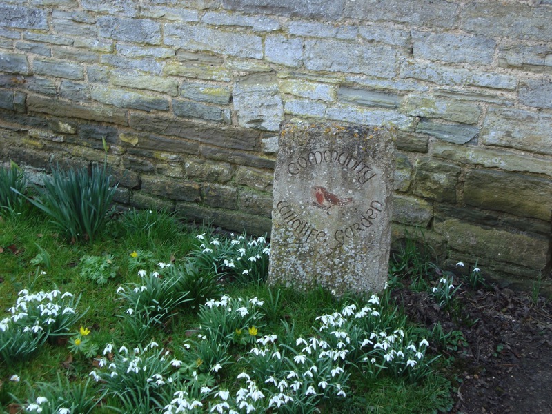
Upcoming events
SNOWDROP PLANTING<
Saturday 6th April 10.30 - MIDDAY
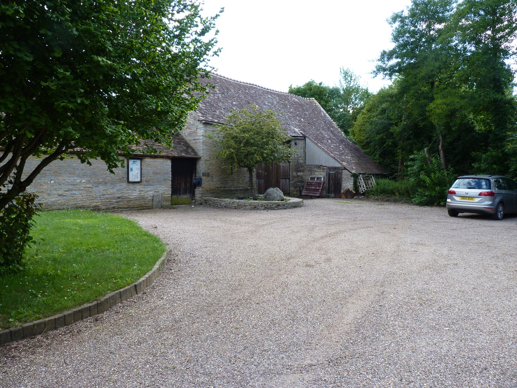
Visit us
Cleeve Prior Heritage Trust
Evesham Rd
WR11 8JX
Registered Charity Number 1063291